Mitchell Woods
Downloads:
No established trails at this time.
Due to the small size of Mitchell Woods there are no available trails. It is a 5-minute walk to the back of the parcel at the boundary with Watkins Forest where several logging trails are being used as walking trails. However there is no available public access except through Mitchell Woods.

Click to see photos of Mitchell Woods
Description:
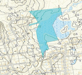
Mitchell Woods was originally used as a sand & gravel pit during construction in this area of town. It contain about 4-acres of dry upland where an open area is located. The remainder of the parcel is a wetlands complex surrounding a substantial marsh along an unnamed brook. The brook joins Baboosic Brook after flowing through Watkins Forest. Mitchell Woods was deeded to the town by Frank & Virginia Twardosky in 1981. Several small abutting parcels of wet/flooded land bordering the brook are owned by the town and managed as Mitchell Woods.
To the north of Watkins Forest is an irregular parcel of land, about 4-5 acres, bordering Baboosic Brook on both sides that in was deeded in 1998 by Klara Sklar to the town. It was conveyed as open space conservation land. Since a portion of it abuts Watkins Forest and access is through Mitchell Woods it too is managed as Mitchell Woods. Other portions of it are accessed from Bean Road and several other small wetland lots are contiguous and are owned by the town.

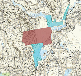
The picture (right) the 2 formal parcels known as Mitchell Woods to the South in light blue. Watkins Forest is shown in the brown color and the Sklar parcel is the light parcel to the North.
Unique/Historic Features:
The large swampy area along the brook is an excellent natural community for many birds and amphibians. Due to the large amount of wetlands located along the unnamed brook and Baboosic Brook the area is important to the quality of our water resources and all of the wildlife dependant on it.
In 2010 the Merrimack Village District searched for additional public supply water wells throughout the town. A potential aquifer resource was located on Mitchell Woods and long-term testing indicated it as a future resource. Testing wells remain on the site and are monitored by the MVD.
Helpful Info
Address:
On Mitchell Street between house lots number 15 and 17. The entrance is along a 50 foot wide corridor between the neighboring parcels with signed boundary lines.
GPS:
42° 52'37.87" -71° 32'08.01"
Permitted Activities:
The Town Administrative Code Chapter 111 determines the permitted activities for the southern most parcel of Mitchell Woods, Tax Map Parcel 6B/224-1. Passive recreation is permitted.
Prohibited Activities:
Use of motorized vehicles, hunting, camping (unless you have a permit) and fires are not permitted. Target Shooting of any kind is not permitted.
Hours of Use:
Mitchell Woods (southern portion) can only be accessed from 1/2 hour before sunrise till 1/2 hour after sunset per Chapter 111 of the Town Code.
Note: The Mitchell Woods entrance is also used to enter the Watkins Forest, a town owned 61-acre parcel, located immediately to the rear of Mitchell Woods. The Watkins Forest does permit hunting and is managed by the Trustees of Trust Funds.